Del Valle Regional Park - Livermore, California
Del Valle Regional Park is located 10 miles south of Livermore, California, in Eastern Alameda County, San Francisco Bay Area. The centerpiece of the park is a 5-mile-long lake that is surrounded by approximately 5,000 acres of oak-studded hills, grasslands, and meadows, perfect for hiking and nature study. For more information, visit Del Valle Regional Park.
Directions
Due to road closures in downtown Livermore for a street festival planned on the same day, we recommend that you avoid any route that takes you near the intersections of Livermore Avenue and Railroad Avenue or First Street.
Via Highway 580:
Utilize the Vasco Road Exit to avoid the downtown Livermore area. Head southbound on Vasco. Turn right onto Tesla. Left onto Mines Road. When Mines curves to the left, stay right to continue to Del Valle Road. Go 4 miles as the road climbs, crests the hill, and then descends to the park entrance. Watch for the Hike for Hope signs. The event staging grounds are at the Fiesta Grande Picnic Area.
Coming from Pleasanton:
Take eastbound Stanley Boulevard. Turn right onto Murietta Boulevard and continue straight as it becomes Fourth Street. Right onto College Avenue. Right onto Tesla. Right onto Mines Road. When Mines curves to the left, stay right to continue to Del Valle Road. Go 4 miles as the road climbs, crests the hill, and then descends to the park entrance. Watch for the Hike for Hope signs. The event staging grounds are at the Fiesta Grande Picnic Area.
Coming from Fremont:
Take Highway 680 North to Highway 84 East. Turn right onto Concannon Boulevard. Right onto Tesla. Right onto Mines Road. When Mines curves to the left, stay right to continue to Del Valle Road. Go 4 miles as the road climbs, crests the hill, and then descends to the park entrance. Watch for the Hike for Hope signs. The event staging grounds are at the Fiesta Grande Picnic Area.
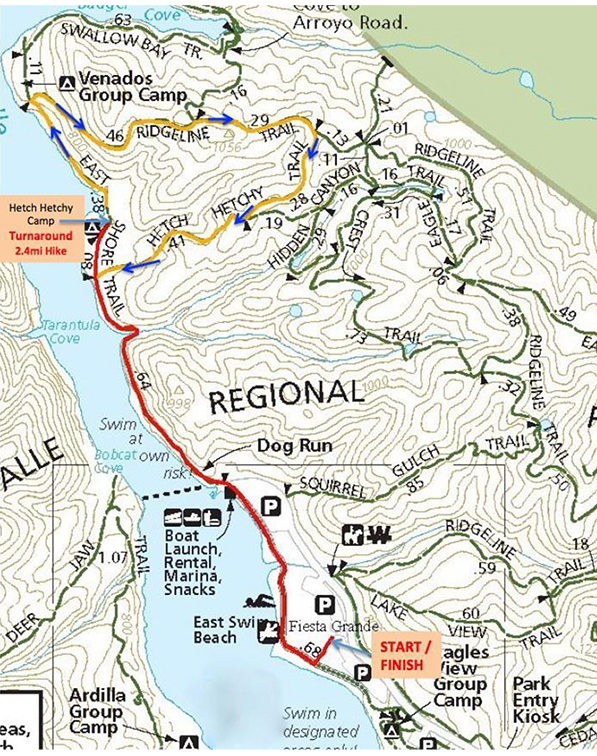
Trail Information
We have two route options and have volunteer safety guides stationed along both routes.
- 2.6 miles – This is an easy out-and-back walk along the lake, which you can shorten to your comfort level.
- 4.4 miles – If you like a bit more challenge, this route adds a moderate incline loop that offers beautiful ridge top views of Mt. Diablo and the surrounding hills.
Click here to download the trail map.