Trail Information
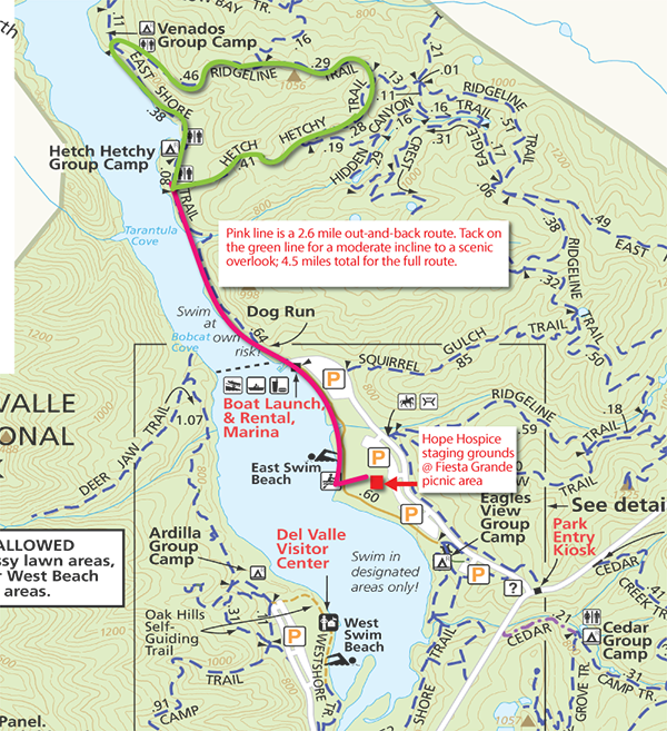
Hike at your own pace. Walk as far as your comfort level along a fairly flat 2.6-mile out-and-back route. Tack on a 2 mile loop with a moderate climb to a scenic overlook. Trail monitors will be positioned along the entire route to help guide the way.
Park Information
Del Valle Regional Park - Livermore, California
Del Valle Regional Park is located 10 miles south of Livermore, California, in Eastern Alameda County, San Francisco Bay Area. The centerpiece of the park is a 5-mile-long lake that is surrounded by approximately 5,000 acres of oak-studded hills, grasslands, and meadows, perfect for hiking and nature study. For more information, visit Del Valle Regional Park.
Parking
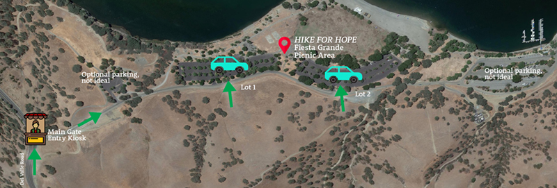
The event staging grounds are at the Fiesta Grande Picnic Area. Two large parking lots are adjacent this space. Look for our signage.
Directions
If you are using GPS, be sure to search for "Del Valle Regional Park Main Gate." Without including "Main Gate," you probably will be sent to a staging ground 20 minutes away from where you should be.
Via Highway 580:
If traveling eastbound: Exit at N. Livermore Road and turn right. Continue on N. Livermore Road for about 1.6 miles; it becomes Tesla Road. Turn right onto Mines Road. Continue on Mines for 3.5 miles. When Mines curves to the left, stay right to continue to Del Valle Road. Go 4 miles as the road climbs, crests the hill, and then descends to the park entrance. Watch for the Hike for Hope signs. The event staging grounds are at the Fiesta Grande Picnic Area.
If traveling westbound: Exit at Vasco Road and turn left. Turn right onto Tesla. Left onto Mines Road. When Mines curves to the left, stay right to continue to Del Valle Road. Go 4 miles as the road climbs, crests the hill, and then descends to the park entrance. Watch for the Hike for Hope signs. The event staging grounds are at the Fiesta Grande Picnic Area.
Coming from Pleasanton:
Take eastbound Stanley Boulevard. Turn right onto Murietta Boulevard and continue straight as it becomes Fourth Street. Right onto College Avenue. Right onto Tesla. Right onto Mines Road.
Continue on Mines for 3.5 miles. When Mines curves to the left, stay right to continue to Del Valle Road. Go 4 miles as the road climbs, crests the hill, and then descends to the park entrance. Watch for the Hike for Hope signs. The event staging grounds are at the Fiesta Grande Picnic Area.
Coming from Fremont:
Take Highway 680 North to Highway 84 East. Turn right onto Concannon Boulevard. Right onto Tesla. Right onto Mines Road. Continue on Mines for 3.5 miles. When Mines curves to the left, stay right to continue to Del Valle Road. Go 4 miles as the road climbs, crests the hill, and then descends to the park entrance. Watch for the Hike for Hope signs. The event staging grounds are at the Fiesta Grande Picnic Area.